PAGASA: Bagyong Yolanda, pinakamalakas na bagyo sa buong mundo ngayong 2013
Summary
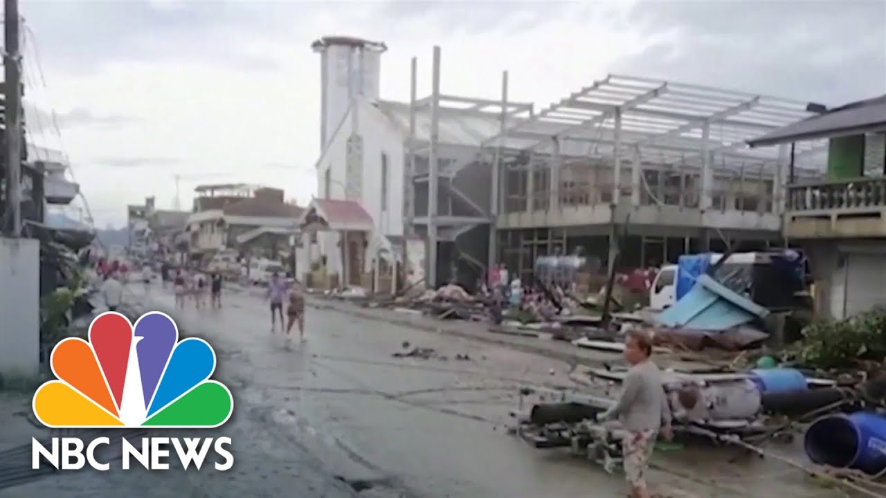
TLDRThe video reports on Super Typhoon Yolanda, described as the strongest storm in the world for 2013, approaching the Philippines with catastrophic force. PAGASA issues storm signals across multiple regions, including Eastern Visayas, Northern Cebu, and parts of Mindanao, with winds reaching 225 km/h and gusts up to 260 km/h. Meteorologist Nathaniel Cruz warns of severe damage to infrastructure, agriculture, and homes, especially in coastal areas. Heavy rainfall and landslides are also expected. Authorities have prepared evacuation centers, emphasizing safety for residents in low-lying or landslide-prone areas. The report stresses vigilance, worst-case scenario preparedness, and continuous monitoring of the storm’s progress.
Takeaways
- 🌪 Super Typhoon Yolanda is one of the strongest storms of 2013, affecting not only the Philippines but globally recognized for its intensity.
- 🌀 The typhoon’s eye was located 384 km east-southeast of Guiuan, Eastern Samar, with maximum sustained winds of 225 km/h and gusts up to 260 km/h, moving northwest at 39 km/h.
- 📍 Storm signal warnings were issued across multiple regions: Signal #4 for Samar, Leyte, Southern Leyte, Biliran, northern Cebu, Capiz, Aklan, and northern Antique; Signal #3, #2, and #1 for other provinces in Visayas, Luzon, and Mindanao.
- 🌧 Heavy rainfall is expected across northern and central Luzon, Southern Luzon, Bicol, the Visayas, and parts of Mindanao due to Yolanda.
- ⛴ Gale warnings were raised for the seaboards of Northern and Central Luzon, with waves potentially exceeding four meters in height.
- 🏠 Damage potential is severe: winds at 225 km/h can destroy light and medium-constructed houses, uproot large trees, and disrupt infrastructure and agriculture.
- 🏢 Evacuation centers have been prepared in stronger, concrete buildings like gyms and churches, prioritizing residents in low-lying and coastal areas to minimize risk.
- 🌊 Aside from strong winds, intense rainfall may trigger flooding and landslides, highlighting the importance of placing evacuation centers in safe areas.
- 🚨 Local officials are coordinating with the National Disaster Risk Reduction and Management Council to ensure readiness and maintain communication, as power outages and communication disruptions are expected.
- 📡 For ongoing updates, GMA Weather provides continuous coverage through their TV channel and social media platforms.
Q & A
What is the name of the super typhoon discussed in the transcript?
-The super typhoon discussed is Typhoon Yolanda.
Which government agency provided the weather update in the transcript?
-The weather update was provided by PAGASA (Philippine Atmospheric, Geophysical and Astronomical Services Administration).
What areas were placed under Storm Signal Number 4?
-Storm Signal Number 4 was issued for the provinces of Samar, Leyte, Southern Leyte, Biliran, extreme northern Cebu including Bantayan Island, Capiz, Aklan, and northern Antique.
What were the wind speeds reported for Typhoon Yolanda?
-Typhoon Yolanda had winds reaching 225 km/h near the center, with gusts up to 260 km/h.
How fast was Typhoon Yolanda moving according to the report?
-The typhoon was moving at a speed of 39 km/h in a west-northwest direction.
Why are the coastal areas particularly at risk during Typhoon Yolanda?
-Coastal areas are at risk because strong winds of up to 225 km/h and heavy rainfall can damage structures, uproot large trees, and cause flooding and storm surges.
What precautions were advised for residents in areas under signal number 4?
-Residents were advised to evacuate to strong, concrete evacuation centers, avoid low-lying areas near rivers, and prepare for heavy rainfall and strong winds.
What is the potential impact of a typhoon with winds of 225 km/h on buildings and infrastructure?
-A typhoon with winds of 225 km/h can destroy houses made of light materials, damage concrete structures, uproot large trees, and cause widespread damage to agriculture, communications, and infrastructure.
What areas were under Gale Warnings and why?
-Gale Warnings were issued for the seaboards of Northern and Central Luzon because of strong northeast winds, even in areas without storm signals, potentially causing waves over four meters high.
How did PAGASA emphasize the importance of disaster preparedness in the report?
-PAGASA stressed that all disaster preparedness activities must be in place, including evacuation to safe centers, monitoring weather updates, and coordinating with local disaster risk reduction offices to minimize casualties and damage.
Which areas in Mindanao were under Storm Signal Number 2?
-Areas in Mindanao under Storm Signal Number 2 included Siargao Island, Dinagat Province, Surigao del Norte, Surigao del Sur, and Agusan del Norte.
Why was Typhoon Yolanda described as the strongest typhoon not just in the Philippines but in the world for that year?
-It was described as the strongest because it had extremely high wind speeds of 225 km/h, with gusts up to 260 km/h, causing widespread potential damage, and surpassing the intensity of other typhoons worldwide in 2013.
Outlines

このセクションは有料ユーザー限定です。 アクセスするには、アップグレードをお願いします。
今すぐアップグレードMindmap

このセクションは有料ユーザー限定です。 アクセスするには、アップグレードをお願いします。
今すぐアップグレードKeywords

このセクションは有料ユーザー限定です。 アクセスするには、アップグレードをお願いします。
今すぐアップグレードHighlights

このセクションは有料ユーザー限定です。 アクセスするには、アップグレードをお願いします。
今すぐアップグレードTranscripts

このセクションは有料ユーザー限定です。 アクセスするには、アップグレードをお願いします。
今すぐアップグレード関連動画をさらに表示
Philippines Struggling After Deadly Typhoon

Tropical storm Megi wreaks havoc across Philippines, 42 killed | WION Climate Tracker | English News

"Stop This Madness": Filipino Climate Chief Yeb Saño Begins Hunger Fast to Protest Global Inaction

Gawad Kalinga brings relief in the Philippines

Press Briefing: SuperTyphoon#PepitoPH{Man-yi} at 5:00 AM | Nov 17, 2024-Sunday

PAGASA - Bagong Julian, posibleng maging super typhoon ngayong... | GMA Integrated News Bulletin
5.0 / 5 (0 votes)
