Japan—Earthquakes & Tectonics (Educational)
Summary
TLDRThe 'Pacific Ring of Fire' is the epicenter of global seismic activity, with Japan at its heart, experiencing over 100,000 earthquakes annually. This region's geological complexity, involving four major tectonic plates, results in frequent quakes and volcanic activity. Notable events like the 1995 Kobe earthquake and the 2011 Tohoku-oki earthquake underscore the importance of preparedness and resilient infrastructure. The 2011 tsunami, a stark reminder of nature's power, has prompted Japan to reassess coastal land use and strengthen disaster readiness.
Takeaways
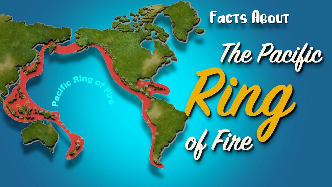
- 🌏 80% of the world's earthquakes occur in the Pacific Ring of Fire, especially along subduction zones.
- 🗻 Japan experiences about 20% of all global earthquakes, with over 100,000 recorded annually.
- 🔍 Seismic activity patterns show a clear distribution from shallow to deep earthquakes along subduction zones.
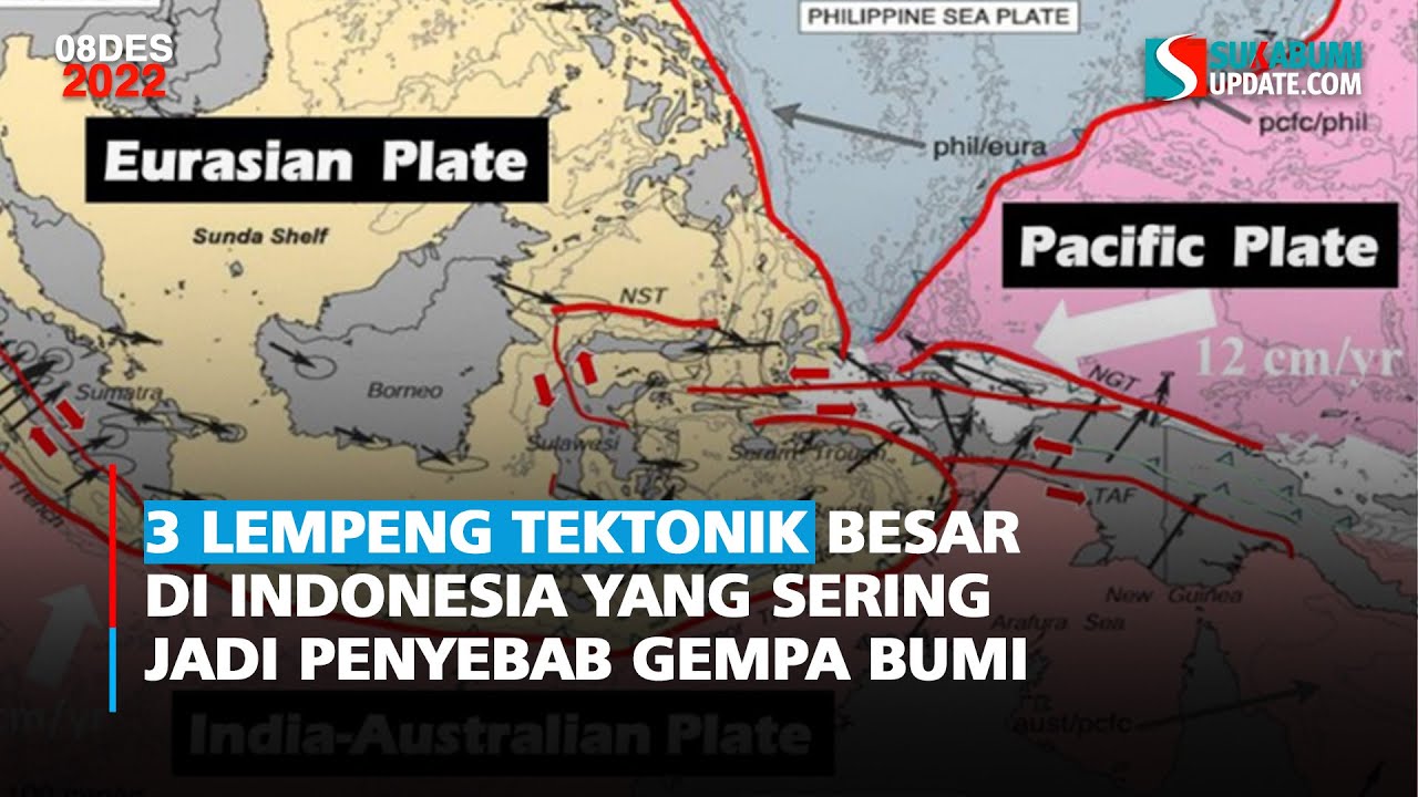
- 🌋 Japan is home to over 100 active volcanoes and is situated at the intersection of four major tectonic plates.
- 📊 The Pacific Plate's subduction beneath the Okhotsk Plate and the Philippine Sea Plate's subduction beneath Japan contribute to the region's seismic activity.
- 🏙️ Major crustal-fault earthquakes occur approximately every 15 years in the region including Kyoto.
- 🚨 The 1995 Great Hanshin (Kobe) earthquake demonstrated the vulnerability of certain structures and the importance of updated building codes.
- 🏗️ Post-1981 structures generally survived the Kobe earthquake with minimal damage, highlighting the effectiveness of building code updates.
- 🌊 The 2011 Tohoku-oki earthquake was a massive event that released a huge amount of energy and caused significant tsunamis.
- 📚 Historical data and geological evidence suggest that subduction zones can store energy for centuries before releasing it in massive earthquakes.
- 🏡 The 2011 tsunami's impact was greater than anticipated, leading to significant loss of life and prompting changes in land-use practices.
Q & A
What is the 'Pacific Ring of Fire' and why is it significant?
-The 'Pacific Ring of Fire' is a region around the Pacific Ocean where about 80% of the world's earthquakes and volcanic eruptions occur. It is significant because of the high concentration of active volcanoes and seismic activity, which poses a significant risk to the regions surrounding it.
How many earthquakes occur in Japan each year, and how many are typically felt by people?
-Over 100,000 earthquakes are recorded in Japan every year, with about 1,500 being strong enough for people to notice.
What is the relationship between earthquakes, volcanoes, and trenches in Japan?
-Earthquakes, volcanoes, and trenches in Japan are all related to the country's location among four major tectonic plates. These geological features are results of the tectonic movements and interactions at convergent margins.
What are the major tectonic plates involved in Japan's seismic activity?
-Japan is situated among the Pacific Plate, the Okhotsk Plate, the Philippine Sea Plate, and the Eurasian Plate. These plates interact through subduction and convergence, causing earthquakes and volcanic activity.
What was the significance of the Great Hanshin earthquake of 1995?
-The Great Hanshin earthquake, also known as the Kobe earthquake, was a magnitude 6.9 earthquake that caused severe damage to the city of Kobe. It resulted in the destruction of over 100,000 buildings and left 300,000 people homeless, highlighting the importance of earthquake preparedness and building codes.
How did the 2011 Tohoku-oki earthquake differ from previous earthquakes in terms of magnitude and impact?
-The 2011 Tohoku-oki earthquake was a magnitude 9 earthquake, which was significantly larger than any earthquake previously recorded in the region. It resulted in a devastating tsunami that caused extensive damage and loss of life, surpassing expectations based on historical data.
What is the maximum depth at which earthquakes have been recorded in Japan?
-Earthquakes in Japan can reach extreme depths of over 500 km, particularly in the subduction zone where the Pacific Plate is subducting beneath the Okhotsk Plate.
What is the connection between the subduction of the Pacific Plate and the generation of tsunamis?
-The subduction of the Pacific Plate can generate tsunamis through megathrust earthquakes, where the sudden movement of the plates causes vertical displacement of the ocean floor, leading to the formation of tsunami waves.
How did the 2011 tsunami differ from previous tsunamis in terms of its reach and height?
-The 2011 tsunami reached greater heights and much farther inland than had been anticipated for tsunamis in the area, resulting in a higher death toll and more extensive damage than expected.
What lessons have been learned from the 2011 earthquake and tsunami that are influencing current land-use practices?
-The 2011 earthquake and tsunami taught that subduction zones can store elastic energy over long periods and release it in massive earthquakes. This has led to changes in coastal land-use practices to decrease the number of people living and working in vulnerable near-shore areas.
Outlines
🌋 Earthquakes and Volcanoes in Japan
This paragraph discusses the high frequency of earthquakes and volcanic activity in Japan, which is largely due to its location along the Pacific Ring of Fire. It mentions that 80% of the world's earthquakes occur in this region, with Japan experiencing about 20% of all measured earthquakes. The country records over 100,000 earthquakes annually, with around 1,500 being strong enough to be felt. The script highlights the subduction-zone boundaries and the interaction of four major tectonic plates that contribute to this seismic activity. It also discusses the historical earthquake patterns and the significant impact of the 1995 Great Hanshin (Kobe) earthquake, which caused extensive damage due to its proximity to a densely populated area. The paragraph emphasizes the importance of understanding seismic activity for disaster preparedness and building codes.
🌊 The 2011 Tohoku-oki Earthquake and Tsunami
The second paragraph focuses on the devastating 2011 Tohoku-oki earthquake and the resulting tsunami. It explains the historical context of earthquake magnitudes along the subduction zone boundary between the Pacific and Okhotsk plates, which led to an underestimation of the potential for a large-scale event. The paragraph details the characteristics of the earthquake, including its magnitude, the area it affected, and the duration of the shaking. It also describes the tsunami's impact, highlighting the unexpected heights and inland reach, which led to significant loss of life and damage. The discussion includes the geological evidence of past similar events and the ongoing efforts in Japan to improve earthquake and tsunami preparedness, including changes in coastal land-use practices.
Mindmap
Keywords
💡Circum-Pacific region
💡Subduction-zone boundaries
💡Active volcanoes
💡Seismic activity
💡Tectonic plates
💡Convergent margins
💡Magnitude
💡Hypocenter
💡Strike-slip fault
💡Tsunami
💡Elastic energy
Highlights
80% of earthquakes worldwide occur around the circum-Pacific region, known as the 'Pacific Ring of Fire'.
Japan experiences about 20% of worldwide measured earthquakes.
Over 100,000 earthquakes are recorded in Japan annually, with about 1,500 strong enough for people to notice.
Seismic activity patterns in Japan show expected shallow to deep earthquakes along subduction zones.
Japan has over 100 active volcanoes along a volcanic arc parallel to oceanic trenches.
Japan is situated among four major tectonic plates, causing earthquakes, volcanoes, and trenches.
The Pacific Plate subducts beneath the Okhotsk Plate at the Japan Trench at a rate of 8.3 cm/yr.
The Philippine Sea Plate subducts beneath Japan at various locations with a rate of 4.5 cm/yr.
Complex structures accommodate slow east-west convergence between the Okhotsk and Eurasian plates.
Major crustal-fault earthquakes occur in the region around Kyoto about every 15 years.
The Great Hanshin earthquake of 1995, also known as the Kobe earthquake, was a right-lateral strike-slip fault rupture.
The 1995 Kobe earthquake resulted in over 100,000 buildings destroyed and 300,000 people homeless.
The 2011 Tohoku-oki earthquake was a magnitude 9 event that ruptured a 500-kilometer-long area.
The Tohoku-oki earthquake's tsunami reached greater heights and farther inland than anticipated.
The 2011 tsunami was caused by vertical displacement of the ocean floor due to the earthquake.
Nearly 20,000 lives were lost in the 2011 tsunami, marking the most costly natural disaster in Japan's history.
Geoscientists found evidence for a similar earthquake and tsunami in 869 A.D., indicating the potential for events larger than previously thought.
Japan is advancing earthquake and tsunami preparedness, including changes in coastal land-use practices.
Transcripts
80% of earthquakes worldwide occur around the circum-Pacific region chiefly along the
subduction-zone boundaries, known as the “Pacific Ring of Fire”, so named because of the more
than 400 active volcanoes that occur there. The earthquake and volcano belt sweeps through
Japan where about 20% of worldwide measured earthquakes occur. There are more than 100,000
earthquakes recorded in Japan every year. Of those about 1,500 are strong enough for
people to notice. By examining the pattern of seismic activity of all earthquakes greater
than magnitude 4 since 2011, we see the expected patterns of shallow to deep earthquakes along
the subduction zones. Over 100 major earthquakes of M7 or larger
have occurred in the past century. Japan also has over 100 active volcanoes. along a volcanic
arc that lies parallel to oceanic trenches, both distinctive features of convergent margins.
. 1 Earthquakes, volcanoes, and trenches all result
from Japan being wedged among four major tectonic plates. The Pacific Plate subducts beneath
the Okhotsk Plate at the Japan Trench. The rate of convergence is 8.3 cm/yr at the location
shown. The Philippine Sea Plate subducts beneath central and southwest Japan at the Sagami
Trough, the Nankai Trough, and the Ryukyu Trench. At the location shown, subduction
is somewhat oblique at 4.5 cm/yr. A complex structure accommodates slow east-west convergence
between the Okhotsk and Eurasian plates. Northwest-directed forces due to subduction,
plus East-West-oriented compression between the Eurasian and Okhokst plates. complicate
the region.” Lets go back millions of years and exaggerate
the tectonics. Now we can see Oblique subduction pushing a forearc crustal block to the west
at a rate of about one half cm/yr). A right-lateral strike-slip fault, called the Median Tectonic
Line, accommodates most of that motion within the Eurasian Plate.
In this region that includes Kyoto, the Imperial Capital of Japan for more than one thousand
years, the earthquake history since the mid-1800s demonstrates that major crustal-fault earthquakes
in this region occur about every 15 years. The most recent example is The Great Hanshin
earthquake of 1995, commonly referred to as the Kobe earthquake.”
Before dawn on January 17, 1995, a right-lateral strike-slip fault ruptured 20 km to the southwest
and 30 km to the northeast from a hypocenter at about 15 km depth. Fault displacement was
3 meters at the hypocenter and 1 meter at 10 km depth beneath Kobe, a port city with
population of 1.5 million. Although this magnitude 6.9 earthquake released
less than 1/1000 th of the energy released during the 2011 Tohoku-oki subduction zone
earthquake, Severe ground shaking and resulting damage was concentrated at locations underlain
by weak, water-saturated sediment and artificial Fill along and within Osaka Bay.
Traditional style houses with a heavy clay-tile roof were vulnerable to collapse while failures
of individual stories or the entire structure affected some multistory buildings. Hundreds
of fires ignited and firefighting efforts were hampered by failures of the water supply
and transportation system. Over 100,000 buildings were destroyed leaving 300,000 homeless. Sections
of the elevated Hanshin Expressway that opened in 1962 collapsed. Most structures completed
after 1981 when building codes were updated, survived with minimal damage. This earthquake
forced a reassessment for tall buildings and transportation infrastructure.
Now let’s look at cross sections of the subduction zones. In northernmost Honshu,
the oceanic Pacific Plate dives beneath the continental Okhotsk Plate. Here we see how
earthquakes outline the subduction geometry. To 70 km depth, thrust-faulting earthquakes
are concentrated at the contact between the plates where megathrust events, often associated
with tsunamis, are generated. Deformation of the overriding plate generates shallow
intra-plate earthquakes. Below 70 km depth, earthquakes occur only within the subducting
plate. Earthquakes in this subduction zone reach extreme depths of over 500+ km because
the Pacific Plate is ~150 Ma old and therefore very cold when it starts to subduct. Plus,
the rate of subduction is fairly rapid at over 8 cm/yr so the oceanic plate is still
cool and brittle at depth. A cross section through central Honshu shows
a slightly steeper subduction angle, thus the volcanoes are closer to the trench. At
the Ryukyu Trench, the angle of subduction is similar to Central Honshu , but the subduction
rate is slower, and the max depth of earthquakes is only 300 km.
“By the late 1800s, written accounts and the beginnings of seismology provide reasonably
accurate information on the location and size of earthquakes off the northeast coast of
Honshu. Running at five years per second, this animation shows the earthquake history
of magnitude 7.4 or larger earthquakes on the subduction zone boundary between the Pacific
and Okhotsk plates from 1896 through 2010. This history led to the impression that earthquakes
on this plate boundary do not exceed magnitude 8.2. That maximum earthquake magnitude and
associated tsunami size became the basis for emergency management, including coastal tsunami
defenses.” Some geoscientists observed that the displacement
between the Pacific and Okhotsk plates during earthquakes of the past few centuries was
much less than the relative plate motion. They were concerned the subduction zone might
be storing elastic energy over many centuries that could be released in a massive earthquake.
On March 11 2011, the Tohoku-oki magnitude 9 earthquake ruptured a 500-kilometer-long
by 200-kilometer-wide area of the plate boundary over an interval of three minutes. Extreme
ground shaking affected coastal towns of northeastern Honshu and strong shaking lasted for 6 minutes
in Tokyo. Superior construction practices and earthquake
preparedness impressively mitigated damage from ground shaking during this earthquake
confirming that Japanese cities often shake but they rarely topple. Unfortunately, the
tsunami generated by the Tohoku-oki earthquake reached greater heights and much farther inland
than had been anticipated for tsunamis in this area.
To understand the 2011 tsunami, let’s view the earthquake rupture process in cross section.
Rupture initiated at the hypocenter, 24 km beneath the seafloor, then propagated both
up-dip to the east and down-dip to the west. Maximum fault displacement reached 40 meters
at a location 50 km from the Japan trench then decreased to 20 m at the trench. These
are the largest fault displacements documented for any earthquake in history. Elastic rebound
during the earthquake caused stations along the coast nearest the epicenter to jump east
by as much as 4.4 meters or 14.5 feet. Seafloor uplift reached 7 meters above the zone of
maximum fault displacement while the seafloor dropped by 2 meters between the epicenter
and the coast. Most of the coastal area subsided during the earthquake. That vertical displacement
of the ocean floor produced the tsunami that rushed onshore within 20 minutes of the earthquake.
In coastal areas where seafloor bathymetry and onshore topography focused wave energy,
the tsunami reached elevations of 40 meters, or 130 feet, above sea level. Although 96%
of citizens successfully evacuated the tsunami inundation zone, nearly 20,000 lives were
lost in this, the most costly natural disaster in Japan’s history.
Centuries of written accounts from this region reported earthquakes and tsunamis, but gave
only vague hints about past events as large as the 2011 event. However, a decade before,
geoscientists searching sedimentary layers upslope of the coast reported tsunami geology
evidence for a similar earthquake in 869 A.D.. Unfortunately, debate about this tsunami geology
was still ongoing when the 2011 earthquake and tsunami struck. This painful lesson taught
us that the subduction zone between the Pacific and Okhotsk plates, and probably others worldwide,
can store elastic energy over 1000-year intervals then release that energy in just a few minutes
during massive earthquakes. As towns in northeast Honshu devastated by the 2011 tsunami are
being rebuilt, changes in coastal land-use practices are being implemented to decrease
the number of people living and working in vulnerable near-shore areas. In this and many
other ways, Japan continues to advance earthquake and tsunami preparedness.
関連動画をさらに表示
PLATE TECTONIC THEORY | Volcanoes, Earthquakes, Mountain Ranges| Grade 10 Science Quarter 1 Module 1
March 11, 2011 Japan Earthquake—10th Anniversary—Lessons Learned (educational)
Predicting Earthquakes: How Japan Is Learning From The Past
Kejeniusan Jepang Membuat Bangunan Tahan Gempa
Japan's Ticking Time Bomb
Inilah asal-usul Lempeng Tektonik, dan iniah alasan Indonesia sering terjadi Gempa Bumi?
5.0 / 5 (0 votes)