Apakah Tsunami Rawan Terjadi di Indonesia?
Summary
TLDRIndonesia, located on the Ring of Fire, is prone to frequent and powerful earthquakes due to tectonic movements. The 2004 Aceh earthquake, one of the most powerful ever recorded, highlighted the region's vulnerability to oceanic disasters. The Mentawai Gap, a major fault line, holds immense energy that could trigger even larger earthquakes in the future. Researchers have been using advanced offshore equipment, such as the Marion Dufresne, to study seismic activity and the ocean floor, enabling better predictions of future earthquakes and tsunamis. This research aims to prepare Indonesia for potential natural disasters, enhancing safety measures for the future.
Takeaways
- 😀 Indonesia is located in a highly seismic region, prone to frequent earthquakes.
- 😀 Out of 171 countries, Indonesia ranks 36th on the World Risk Index for natural disasters.
- 😀 The 2004 Aceh earthquake was one of the most powerful ever recorded, triggering a massive tsunami.
- 😀 The possibility of another similar or even worse oceanic disaster is high, due to Indonesia's seismic location.
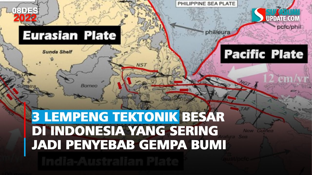
- 😀 Indonesia lies on two of the world’s most active seismic belts, making it highly vulnerable to earthquakes.
- 😀 The Ring of Fire is a significant area of seismic activity, with volcanoes both on land and under the sea.
- 😀 The Ring of Fire was formed by the movement of Earth's tectonic plates, which can collide, split, or slide past each other.
- 😀 Tectonic plate movements at faults, such as the Sunda Megathrust, are major causes of earthquakes in the region.
- 😀 Research following the 2004 disaster revealed complex causes for subsequent large earthquakes in the area.
- 😀 The Mentawai Gap, a part of the Sunda Megathrust, holds a massive amount of energy and could cause a massive earthquake if it ruptures.
- 😀 Offshore research vessels, like Marion Dufresne, use advanced technology to study the ocean floor and gather important data about earthquake faults.
- 😀 Understanding the structure of earthquake faults and seismic risks helps us prepare for future earthquakes and tsunamis.
- 😀 The goal is to be more prepared in case a disaster similar to the 2004 Aceh earthquake happens again.
Q & A
Why is Indonesia frequently affected by earthquakes?
-Indonesia is located on two of the world’s most active seismic belts, making it highly susceptible to frequent earthquakes.
Where does Indonesia rank on the World Risk Index, and what does this indicate?
-Indonesia ranks 36th on the World Risk Index out of 171 countries, which indicates its vulnerability to natural disasters like earthquakes and tsunamis.
What significant event occurred in 2004 in Indonesia?
-In 2004, one of the most powerful earthquakes ever recorded struck Aceh and the surrounding areas, triggering a giant tsunami.
Is there a possibility of another oceanic disaster similar to the 2004 tsunami?
-Yes, another oceanic disaster could occur in the future, potentially even worse than the 2004 tsunami, due to Indonesia’s location in active seismic zones.
What is the Ring of Fire, and how is it related to Indonesia’s seismic activity?
-The Ring of Fire is a region of the Pacific Ocean characterized by frequent earthquakes and volcanic activity. Indonesia is part of this zone, which contributes to its seismic activity.
How are tectonic plate movements related to earthquakes?
-Tectonic plates, which make up the Earth’s crust, can collide, split apart, or slide past one another, creating faults. The shifting of these plates is a primary cause of earthquakes.
What did researchers discover about the causes of earthquakes in the Sumatran west coast after 2004?
-After 2004, researchers found that the causes of earthquakes in the Sumatran west coast were complex, with different explanations from various scientific fields, including the origin of the 2010 and 2012 earthquakes.
What is the Mentawai Gap, and why is it significant in earthquake studies?
-The Mentawai Gap is a section of the Sunda Megathrust fault that holds a significant amount of energy but hasn't ruptured for centuries. If it were to rupture, it could trigger a massive earthquake.
How do offshore research vessels contribute to earthquake studies?
-Offshore research vessels like Marion Dufresne are equipped with sophisticated devices that allow researchers to take seabed samples, map the ocean floor, and perform seismic surveys to study the Earth’s layers and better understand earthquake faults.
What is the importance of understanding oceanic tectonics in earthquake prediction?
-Understanding oceanic tectonics helps scientists anticipate potential earthquake and tsunami hazards by providing data on the structure and behavior of faults, improving preparedness for future disasters.
Outlines

Dieser Bereich ist nur für Premium-Benutzer verfügbar. Bitte führen Sie ein Upgrade durch, um auf diesen Abschnitt zuzugreifen.
Upgrade durchführenMindmap

Dieser Bereich ist nur für Premium-Benutzer verfügbar. Bitte führen Sie ein Upgrade durch, um auf diesen Abschnitt zuzugreifen.
Upgrade durchführenKeywords

Dieser Bereich ist nur für Premium-Benutzer verfügbar. Bitte führen Sie ein Upgrade durch, um auf diesen Abschnitt zuzugreifen.
Upgrade durchführenHighlights

Dieser Bereich ist nur für Premium-Benutzer verfügbar. Bitte führen Sie ein Upgrade durch, um auf diesen Abschnitt zuzugreifen.
Upgrade durchführenTranscripts

Dieser Bereich ist nur für Premium-Benutzer verfügbar. Bitte führen Sie ein Upgrade durch, um auf diesen Abschnitt zuzugreifen.
Upgrade durchführenWeitere ähnliche Videos ansehen


5.0 / 5 (0 votes)
